Note: The Mt. Qilai Trail extends beyond the Xiaoqilai Trail (The first section from the trailhead to 1.4 km is Xiaoqilai trail).
Trail Introduction
The trail entrance to Xiaoqilai is located at the base of Mt. Hehuan East Peak . The path from the road at the Mt. Hehuan Visitor Center to the trail entrance gently slopes downhill and can accommodate 4-wheeled vehicles. Here, hikers can see the Qilai Mountains, Mt. Ju, Mt. Yangtou, and the Liwu River over the horizon. Past the ski resort, hikers reach the trail entrance where the path travels across plains of Yushan cane (Yushania niitakayamensis) 2-3 m high. The landscape then transitions into a forest comprised of Taiwan fir ( Abies kawakamii) where the path undulates uphill and downhill, eventually reaching Xiaoqilai, which is covered in a second plain of Yushan cane. Here, the layers of hills remind hikers of undulating waves.

Past this point, the hiking trail leads to the Main and North Peaks of Mt. Qilai, both of which require a multi-day itinerary. Hikers will need to arrange sufficient equipment and both Mountain Access and Park Access Permits to venture past Xiaoqilai. The Xiaoqilai Trail therefore ends at this point, and unless heading to Mt. Qilai, hikers will need to turn around upon reaching the bamboo fields and return via the original route.
Geology
The Xiaoqilai Trail is relatively spacious, with water-filled depressions and two hills, the highest at 3,150 m above sea level. The majority of the trail also offers a panoramic view of the undulating hills over the horizon. Following a forest fire at the beginning of the millennium, the Xiaoqilai trail was then shaped by erosion from several bouts of heavy rain and the collapse of previous steep hills, creating a gently sloping, concave-shaped terrain. At Xiaoqilai, hikers are able to see the two neighboring peaks of Mt. Qilai farther along the trail, with Mt. Hehuan also visible in the opposite direction. On a clear day, the main peak of Jade Mountain may also be visible towards the south. Xiaoqilai is part of the ridgeline connecting Mt. Hehuan and Mt. Qilai that separates two valleys. Water collected within the eastside valley supplies the upstream section of the Liwu River , while the source of the Zhuoshui River lies in the west valley, flowing all the way to Taichung.
Ecology
The first part of the Xiaoqilai Trail is dominated by plains of alpine Chinese Silvergrass ( Miscanthus sinensis), with thickets of alpine roses ( Rosa polyantha) and Japanese knotweed ( Fallopia japonica) interspersed amongst the grassland. The forest section following the plains is cold, gloomy, and humid—except for some Yushan cane that have sought out the spots of sunshine, mossy plants thrive on the dark and damp forest floor. Where more sunlight penetrates through the forest canopy, thickets of false-gold-flower rhododendron (Rhododendron pseudochrysanthum), Taiwan juniper (Juniperus formosana), and other shorter alpine plants are able to grow.
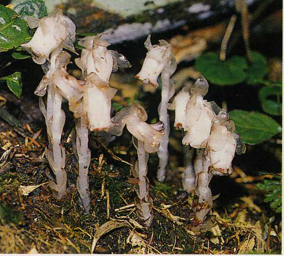
Trail Highlight: Indian pipe
In the summer, a crystal-like translucent plant silently germinates from the darkest corners of the somber forest floor on the Xiaoqilai Trail. The flowers of the Indian pipe (Monotropa uniflora) have the same crystal-like quality as the rest of plant body, especially given that they snap at the gentlest brush of a hand.
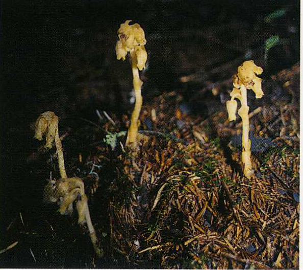
Trail Highlight: Pinesap
Though similar to the Indian pipe at first glance, multiple flowers will bud on a single Pinesap (Monotropa hypopitis) stem, as opposed to a single single flower at the tip of the stem of an Indian pipe. The colour of the entire pinesap is a pale yellow, and the plant often grows below the bamboo canopy.
Trail Highlight: Yushan Cane
During the summer, the verdant Yushan cane fields (Yushania niitakayamensis) provide a pleasing tranquility to the Xiaoqilai Trail. Research shows that, originally, Taiwan white fir (Abies kawakamii) dominated the Xiaoqilai region; however, successive forest fires progressively burned down all trees and shrubbery, providing a clean slate for primary succession. Given that the underground stems of the Yushan cane were not completely destroyed, this species gradually spread across the entire region, and continue to multiply to this day.
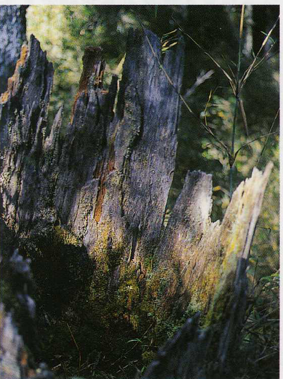
Trail Highlight: The Ecological Succession of Deadwood
When walking along the Xiaoqilai Trail, hikers may notice dead trees standing upright or fallen across the trail. To humans, they may not be very useful; however, they play an important role in the cyclic succession of new organisms. The life and death of trees are a crucial component of the ecological cycle, and deadwood is important to maintain the natural order of this environment.
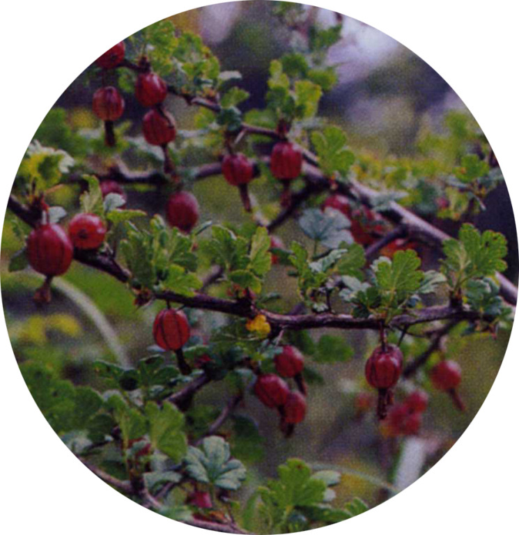
Trail Highlight: Formosan Gooseberry
The red, globular berry that is the central component of the Formosan Gooseberry (Ribes fasciculatum) appears during autumn, and, hanging at the ends of slender branches, resembles a red lantern hanging high above the ground.
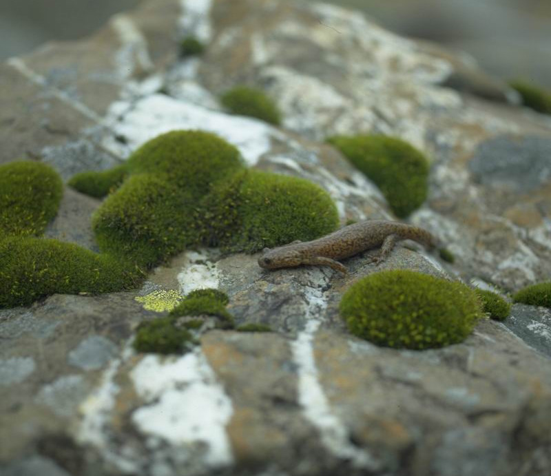
Trail Highlight: Formosan Salamander
The Formosan salamander (Hynobius formosanus) is an endemic species, having been in Taiwan since the last glacial maximum. Following the most recent glacial retreat more than 10,000 years ago, the accompanying climate warming has restricted the habitat of the Formosan salamander to the high mountains of Taiwan, over 2,000 meters in elevation.
Resources